After your well is drilled, your driller files a document called a well report (sometimes called a well log) with the Washington State Department of Ecology. You'll get a copy too. It's one of the most important documents associated with your property — and most well owners never look at it.
That's a mistake. Your well report tells you exactly what's under your land, how your well was built, and how much water it produces. Whether you're a new well owner trying to understand what you've got, or a buyer evaluating a property with an existing well, this guide breaks down what's on the report and why it matters.
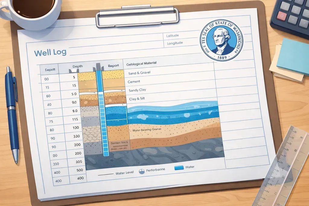
What Is a Well Report?
In Washington State, every well driller is required by law to file a well construction report with the Department of Ecology within 30 days of completing a well. This report becomes a public record — anyone can look it up in the state's well log database.
The report documents everything about your well: where it is, how deep it goes, what the driller found underground, how the well was constructed, and how much water it produces. Think of it as the birth certificate for your well.
Key Sections of the Report
Well Location
The report identifies your well's location using township, range, and section coordinates — the legal land description system used in Washington. It also includes the county, the property owner's name, and sometimes GPS coordinates. This is how the state tracks which well belongs to which property.
Well Depth
This tells you the total depth of the borehole in feet. In Eastern Washington, residential wells typically range from 80 to 400+ feet depending on your location. The depth determines a lot about your well — deeper wells generally cost more but often access more reliable aquifers.
Geology Log
This is the most interesting part for most people. As the driller bores through the ground, they document what they encounter at each depth — topsoil, clay, sand, gravel, basalt, fractured rock, and so on. In our part of Eastern Washington, you'll typically see layers of Columbia Plateau basalt interspersed with sedimentary layers.
The geology log tells you what kind of ground your well passes through and where the water-bearing zones are. This information is valuable if you ever need to drill a second well, deepen your existing one, or troubleshoot water quality issues.
Water-Bearing Zones
The report notes at what depth(s) the driller hit water and how much water was coming in. You might see entries like "water-bearing zone at 180 feet" or "static water level at 120 feet." These numbers tell you:
- Where the water is — which geological layer is actually producing water
- Static water level — how high the water naturally sits in the well when the pump is off. This is important for sizing your pump correctly.
- Whether there are multiple zones — some wells pass through several water-bearing layers at different depths
Well Yield (Flow Rate)
The yield tells you how many gallons per minute (GPM) your well produces. This is one of the most important numbers on the report. For a typical household, 5 GPM is generally considered adequate. Many wells in Eastern Washington produce significantly more — 10, 20, even 40+ GPM depending on the aquifer.
A low yield doesn't necessarily mean a bad well. Even a 2-3 GPM well can serve a household if paired with a properly sized pressure tank and storage system. But it's a number you want to know and plan around.
Casing and Construction Details
The report documents how the well was built: the casing material (usually steel), diameter (commonly 6 inches for residential), how deep the casing extends, and how the annular space (gap between casing and borehole) was sealed. Proper sealing with grout or bentonite is critical — it prevents surface water and contaminants from reaching your groundwater.
Pump Test Results
Most reports include the results of a pump test conducted after drilling. The driller pumps water at a sustained rate and measures how the water level responds. This tells you how the aquifer performs under demand — not just what it looks like when it's sitting still. Key numbers include the pumping rate, drawdown (how far the water level drops during pumping), and recovery time (how quickly it bounces back).
Why Your Well Report Matters
- Property transactions — Buyers and their lenders often want to see the well report before closing. It's proof that the well exists, was properly constructed, and produces water.
- Pump sizing — Your pump installer needs the well depth, static water level, and yield to select the right pump. This info comes straight from the report.
- Troubleshooting — If you develop water quality issues or declining yield years later, the original well report provides the baseline to compare against.
- Future drilling — If you ever need a second well or want to deepen an existing one, the geology log saves time and money by showing what's already been encountered underground.
How to Find Your Well Report
Washington State maintains a public well log database through the Department of Ecology. You can search by location, owner name, or well tag number. If you can't find yours online, your driller should have provided a copy at the time of drilling — check your property files.
If you're buying property with an existing well, ask the seller for the well report. If they don't have it, search the state database. No report on file could be a red flag — it might mean the well was drilled before modern reporting requirements, or that it wasn't constructed by a licensed driller.
What to Do With This Information
Keep your well report somewhere safe — with your deed, insurance documents, and other property records. If you ever sell the property, the buyer will want it. If you ever need well service, the technician will want it. And if you're ever curious about what's 200 feet below your backyard, it's the only document that tells you.