When you turn on the faucet in a home with a well, the water that comes out has been on a long journey — one that started as rain or snow, sometimes years or even decades ago. Understanding where that water comes from, how it gets to your well, and what happens along the way isn't just interesting trivia. It actually helps you make better decisions about your well, your water quality, and how to protect both for the long haul.
What Is Groundwater, Really?
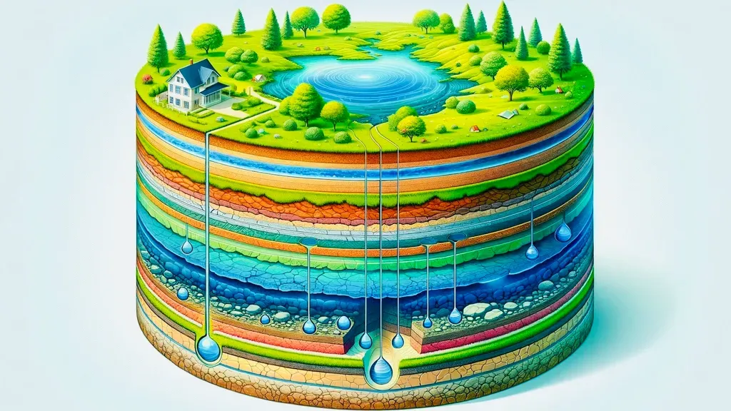
Let's start with the basics. Groundwater is simply water that exists underground, filling the tiny spaces, cracks, and gaps in rock and soil beneath the surface. It got there the same way puddles form on the surface — from precipitation. Rain falls, snow melts, and some of that water soaks into the ground instead of running off into streams and rivers.
As that water seeps downward through soil and rock, gravity pulls it deeper until it reaches a zone where all the available spaces are completely filled with water. That saturated zone is where your well draws from. It's not as dramatic as people sometimes imagine — there are no rushing underground rivers in most places — but the amount of water stored in rock and soil beneath our feet is enormous. In the United States, there's actually more freshwater stored underground than in all our surface lakes and rivers combined.
Key Terms You'll Hear (Explained Simply)
There's some terminology that comes up a lot when talking about groundwater. Here's what these words actually mean in plain language:
- Aquifer: A layer of rock or sediment that holds and transmits water. Think of it like a sponge made of rock — it's saturated with water, and that water can move through it. Some aquifers are incredibly productive; others yield only a trickle. The type of rock matters enormously.
- Water table: The boundary between the saturated zone (full of water) and the unsaturated zone above it (where air still fills some of the spaces). When people say "the water table is at 100 feet," they mean you'd hit fully saturated rock at that depth. The water table isn't fixed — it rises and falls with the seasons, precipitation, and usage.
- Recharge area: The area on the surface where water enters the ground and eventually makes its way down to an aquifer. For some aquifers, the recharge area might be miles away from where the water is eventually pumped out. Protecting recharge areas from contamination is critical for long-term water quality.
- Artesian pressure: In some geological situations, water in an aquifer is under natural pressure — squeezed between impermeable layers of rock above and below. When a well taps into an artesian aquifer, the water rises up in the well on its own, sometimes all the way to the surface without any pumping needed. It's not magic — it's just physics and geology working together.
Eastern Washington's Geology: The Basalt Aquifer System
To understand the groundwater in our area, you need to know a little about what's under your feet. And here in Eastern Washington, that story is volcanic.
Millions of years ago, massive lava flows covered this region — layer after layer of basalt, sometimes thousands of feet thick in total. These are the Columbia Plateau basalt formations, and they're the dominant geological feature across much of Lincoln, Stevens, and Spokane counties.
Here's what makes this geology interesting for wells: between those basalt layers, there are zones where water collects and moves. The contact zones between individual lava flows — where one flow cooled and the next one poured over it — tend to be fractured, rubbly, and permeable. Water moves through these interflow zones, and that's where most wells in our area find their water.
There are also sedimentary interbeds — layers of soil, sand, or gravel that were deposited between volcanic events — that can hold significant amounts of water. And the tops and bottoms of individual basalt flows tend to be more fractured than the dense centers, creating additional pathways for water.
The result is an aquifer system that's layered like a cake, with multiple water-bearing zones stacked at different depths. That's why well depths in our area can vary so much — one property might hit a productive zone at 80 feet, while the next one over needs to go 300 feet or more to find adequate water. It depends on which layers are present and where the fractures and interbeds sit.
How Groundwater Moves
One of the biggest misconceptions about groundwater is that it flows like an underground river. In most cases, it doesn't. Groundwater moves very slowly — typically inches to feet per day — seeping through tiny pores in rock and sediment or creeping along fractures in harder formations like basalt.
The direction and speed of movement depend on the geology. Water moves from areas of higher pressure (or elevation) toward areas of lower pressure, following the path of least resistance through whatever permeable material is available. In our basalt aquifers, water tends to move laterally along those interflow zones we talked about, following the slight tilt of the rock layers.
This slow movement is actually a good thing for water quality. As water travels through rock and soil, it gets naturally filtered. Bacteria, sediment, and many contaminants are removed or reduced over the course of that journey. It's nature's own filtration system, and it's remarkably effective — which is why groundwater from deep aquifers is generally cleaner than surface water.
Why Well Depth Varies So Much
We get this question a lot: "My neighbor's well is only 120 feet deep — why does mine need to be 250 feet?" The answer comes down to geology, and specifically to the fact that geological formations aren't uniform, even across short distances.
A basalt layer that's fractured and water-bearing on one property might be dense and impermeable a quarter mile away. Sedimentary interbeds pinch out. Fault lines shift layers up or down. The geology is three-dimensional and complex, and the water-bearing zones don't follow property lines.
This is why looking at neighboring well logs is so valuable — it gives us a picture of what the subsurface looks like in your area — but it's also why we can never guarantee an exact depth before drilling. We can give you a well-informed range based on the data, but the rock tells the final story.
Groundwater Quality in Eastern Washington
The good news is that groundwater quality across most of Eastern Washington is generally good. The natural filtration provided by basalt and sedimentary layers does an excellent job of producing clean water. Most wells in our service area produce water that's safe to drink with little or no treatment.
That said, there are some characteristics that are common in our area:
- Hard water — elevated calcium and magnesium from dissolving through mineral-rich rock. Not a health concern, but it can affect your plumbing and appliances over time.
- Iron and manganese — these naturally occurring minerals can cause staining and affect taste. Some areas have more than others.
- Naturally occurring arsenic — certain geological formations in Eastern Washington contain arsenic that can dissolve into groundwater. Levels vary by area, and testing is the only way to know.
Annual water testing is important for any well owner, but especially so in a region where these natural minerals are part of the geology.
Is the Water Going to Run Out?
This is a question that's been getting more attention in recent years, and it's a valid concern. Aquifers are replenished through a process called recharge — precipitation soaks into the ground, percolates down through the soil and rock, and eventually makes its way back to the aquifer. As long as recharge keeps up with pumping, the water supply is sustainable.
For most residential wells in Eastern Washington, the answer is reassuring. Individual household wells pump relatively small amounts of water compared to agricultural or municipal wells, and the basalt aquifer system has significant storage capacity. The vast majority of homeowners with private wells are not at risk of running their aquifer dry.
That said, sustainability isn't something to take for granted. In some areas where large-scale agricultural irrigation draws heavily from the same aquifers, water levels have been declining over time. And climate patterns matter too — Eastern Washington gets significantly less rainfall than the western side of the state, though snowpack from the mountains contributes meaningfully to groundwater recharge during spring melt.
The bottom line is that responsible use and proper well construction are the best things individual well owners can do to ensure long-term water availability.
Protecting Your Groundwater
Because groundwater moves slowly and can take years to travel from the surface to an aquifer, contamination can be a long-term problem once it happens. Prevention is far easier and cheaper than cleanup. Here are the most important things well owners can do:
- Proper well construction is your first line of defense. A well with a solid grout seal prevents surface water — and anything it carries — from reaching the aquifer via the bore hole.
- Maintain your septic system. In rural areas, septic systems and wells share the same landscape. A failing septic system can contaminate the groundwater that feeds your well and your neighbors' wells.
- Don't dump chemicals on the ground. Pesticides, fertilizers, motor oil, solvents — anything you put on or in the ground can potentially make its way to the water table. It might take years, but it can get there.
- Protect your wellhead. Make sure the well cap is secure and the area around the wellhead is graded so surface water drains away from it rather than pooling around it.
Climate and Recharge in Eastern Washington
Eastern Washington sits in the rain shadow of the Cascade Range, which means we get considerably less annual precipitation than the western side of the state — typically 10 to 20 inches per year across much of our service area, compared to 40 or more inches on the coast.
But precipitation isn't the whole story. Snowpack plays a significant role in groundwater recharge in our region. Snow that accumulates in the mountains and higher elevations during winter melts gradually in spring, providing a slow, sustained source of water that soaks into the ground rather than rushing off as runoff. This slow-release pattern is actually more effective at recharging aquifers than the same amount of rainfall would be.
Climate variability — drier years, lower snowpack, earlier spring melts — does affect recharge over time. It's another reason why responsible water use and proper well management aren't just good practice; they're important for the broader community that depends on these shared aquifers.
Bringing It All Together
Groundwater might be invisible, but it's the resource your well depends on every day. Understanding the basics — how it forms, where it sits in the rock, how it moves, and what can affect its quality and quantity — makes you a more informed well owner. And informed well owners tend to have fewer problems, better water quality, and wells that last longer.
If you're curious about the groundwater conditions on your property or have questions about what's happening with your well, don't hesitate to reach out. This is what we do every day, and we're always happy to talk about the water under your feet.